We’ll see how satellites locate the ground stations to establish connections, and some intuitive math behind finding the line of sight communication.
Earth observing satellites are mostly Sun Synchronous Lower Earth Orbit satellites. Meaning, they have highly inclined, near-earth-surface orbits. They carry out their observations, collect the data and send it back to ground stations when the connection can be established. LEO satellites are very near to earth and most of their field of view is covered by small section of Earth surface. They can contact Ground stations(GS), only if the it is in the visible section of Earth’s surface. In fact, a satellite orbiting at around 500km above earths surface can be in Contact with a ground station for only about 10% of its orbital time. Satellites collect the data during their orbit and send to the GS during this "In Contact” period. They have to actively adjust their antennas and point towards the Ground station.
To point their antenna towards a ground target, satellites have to know the positions and orientations of themselves and the target. For doing the calculations, spacecraft engineers make use of the comfort provided by reference frames.
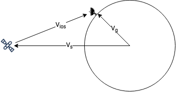
To make the math simpler, we convert the position of the satellite(Vsat) & GS(Vgs) into a same reference frame. These conversions are as simple as Matrix multiplications. In terms of same reference frame, line of sight vector (Vlos) can be simply obtained by subtracting the two position vectors Vsat & Vgs.
And next, the question is, which reference frame should we pick? Perhaps the frame of satellite? Or the Earth ? Or may be the Sun’s? The downside of all of them is, they Rotate. Rotation unnecessarily add a magical and invisible outward force on all the bodies. And it can be confusing to make force related calculations in these frames. So, for this problem, we will have to choose an inertial reference frame, and one such popular frame with its center coinciding with Earth’s centre is ECI Frame (Earth Centred Inertial Frame).
Now let's convert both vectors in to ECI frame:
In the frame of satellite's orbit,
| $$ V_{sat, orbit} = \begin{bmatrix} r_{sat}*cos(\Omega*t) \\ r_{sat}*sin(\Omega*t)\\ 0 \end{bmatrix} $$ |
As t in the above equation varies, the vector traces the following path:
Here we approximated the satellites orbit with a circle.
rs is the radius of satellite orbit and θ is the satellite's initial orbital angular position.
Since the satellites orbit is inclined about the equatorial plane of earth, we need to convert Vsat into inclined plane reference frame. The euqivalent rotation matrix for inclination(i) about X-axis is:
| $$ E_{inclined, orbit} = \begin{bmatrix} 1 & 0 & 0 \\ 0 & cos(i) & -sin(i)\\ 0 & sin(i) & cos(i) \end{bmatrix} $$ |
So,
| $$ V_{sat, inclined} = E_{inclined,orbit} * V_{sat, orbit} $$ |
Finally convert Vsat, inclined from reference frame of inclined orbit to Earth Centered Inertial Frame.
If the initial offset between X axis of Incliend ref. frame & X axis of ECI frame is Ω, then the rotation matrix is:
| $$ E_{ECI, inclined} = \begin{bmatrix} cos(\Omega) & -sin(\Omega) & 0 \\ sin(\Omega) & cos(\Omega) & 0\\ 0 & 0 & 1 \end{bmatrix} $$ |
Then again,
| $$ V_{sat, ECI} = E_{ECI,inclined} * V_{sat, inclined} $$ |
We take lat & lon of the ground stations as input to calculate the vector Vgs, ECI
After all the rotations,
As the time varies, the vector in ECI frame rotates this way:
| $$ V_{los, ECI} = V_{sat, ECI} - V_{gs, ECI} $$ |
Line of sight only makes sense if the line is free from any obstacles. So, when the satellite is below the horizon of the Ground station, there is no direct lien of sight and the satellites using LOS communication systems cannot establish a connection
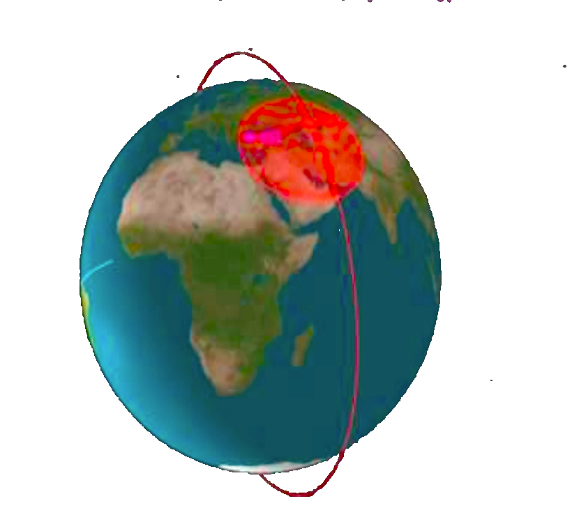
All the above simulations looks more mathematical, unless until the Earth comes into picture.